 Skip to content


What a La Nina Winter Means for Utah
Earlier this fall, the National Oceanic and Atmospheric Association (NOAA) issued a US Winter Outlook. The long-range forecast noted that there’s an ongoing La Niña event, which typically brings drought to a large swath of the country.
Right now, NOAA is giving us about a fifty fifty chance of La Niña. The event currently is pretty weak, but there’s a chance it could strengthen before it impacts the Northern Hemisphere.
Here’s everything you need to know about this climate pattern and how it could affect your season. This is a must-read for anyone who snowboards.
How La Niña Does to Winter Temperatures
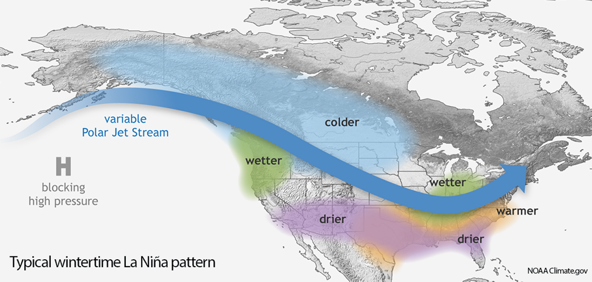
The temperature outlook is not looking good for Utah, California, Nevada, Colorado, and the Northeast.
In the central and southern part of the Beehive State, there’s a 40% to 50% percent chance of warmer than average temperatures. Good for climbing or mountain biking. Not so good for Brian Head and Eagle Point, your fantasy hut trip to the La Sals, or the powder snowboards in your garage.
In the northern part of the state, including resorts along the Wasatch Front and the Uintas, there’s a 33% to 40% chance of warmer than average temperatures.
Now What About That Moisture?
Southern Utah, southern Colorado, most of California, New Mexico, and Arizona are forecasted to have drier than normal precipitation. That means Taos, Wolf Creek, and most likely Tahoe have a bleak-looking winter ahead of them.
The rest of Utah, northern Colorado, the greater Jackson Hole area, and southern Oregon have equal chances for wetter than average and drier than average precipitation. Same goes for the Northeast.
A glimmer of hope: there’s a little pocket of higher than average precipitation forecasted for Salt Lake County as well as central Colorado. That increases your chances of being able to use those sought-after reserved dates on your Epic Pass.
That being said, the name of the game for reliable snowfall is to head north. The Pacific Northwest and the northern part of the Intermountain West are sitting pretty with this long-term forecast. Average precipitation is forecasted to be between 110% and 127% of normal.
Parts of southern coastal Alaska also look like they’ll get hammered, Haines in particular.
Historic La Niña Winters: What Happen in Utah and What to Expect
OpenSnow forecaster Evan Thayer identified 22 Utah winters since 1950 that had either a moderate or strong La Niña event. Half of them fell below the seasonal average at NOAA’s Alta-Guard automated weather station. The other half had higher than average snowfall.
Bottomline
La Niña winters are a toss up for Utah snowboarders. Strong events have produced some of the biggest seasonal snowfalls the Wasatch Front has ever seen. They’ve also brought long periods of drought and bouts of high pressure.
Winter 2022/2023 might be the year to plan a trip to Mt. Baker, Mt. Hood, Schweitzer, or virtually anywhere in Montana. It will be cold and wet throughout the northern Pacific Northwest and upper Intermountain regions.